

Northants · NN29
Bozeat
Offers in Region of
An exceptional redevelopment opportunity extending to approximately 0.79 acres, situated in a non-estate rural setting close to the sought-after village of Bozeat. The site benefits from detailed planning consent for the demolition of the existing dwelling and erection of a substantial five-bedroom detached home with double garage. - TO REQUEST FURTHER DETAILS OR ARRANGE A VIEWING, CONTACT COMPASS LAND ON 01234 351 577
The home, in the agent’s words
- Rare redevelopment plot extending to approximately 0.79 acres
- Non-estate semi-rural location close to Bozeat village
- Full planning permission for a 5-bedroom detached house
- Proposed new build of approximately 3,939 sq ft (GIA) over three floors
- Includes double garage within the approved scheme
- Existing adjacent building, consented for conversion to a to 2-bedroom dwelling on 0.34 acre plot, is available by separate negotiation
- Excellent self-build or developer opportunity
- Convenient access to Wellingborough, Northampton, Milton Keynes and Bedford
Read the full agent description
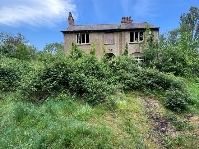
A rare opportunity to acquire a substantial redevelopment plot extending to approximately 0.79 acres, set in a non-estate, semi-rural location close to the sought-after village of Bozeat. The site benefits from detailed planning consent for the demolition of the existing dilapidated dwelling and the erection of an impressive five-bedroom detached house with a double garage. The proposed new house will extend to approximately 3,939 sq ft (GIA) arranged over three floors, offering an ideal self-build or bespoke development opportunity.
The plot enjoys a peaceful setting while remaining conveniently positioned for access to nearby amenities in Bozeat. It lies approximately 1.5 miles from Bozeat, a well-regarded village offering a primary school, local shop, public house, church, playing fields, and a central green used for community events. The nearby village of Harrold is approximately 3 miles away, providing further facilities. Bozeat itself is situated around 6 miles south of Wellingborough on the A509, offering excellent road links to Northampton, Milton Keynes and Bedford, making it particularly attractive for commuters.
Planning application was submitted under reference 26/00522/FUL, validated on 25th February 2026, for the demolition of the existing dwelling and replacement with a substantial detached residence. This application is a resubmission of a previously approved scheme (ref NW/23/00378/FUL), with a current determination date of 17th July 2026. Interested parties are advised to make their own enquiries in relation to any potential CIL liability.
The existing property on site is dilapidated, overgrown and in need of demolition to facilitate redevelopment. Adjacent to the main plot, is an additional parcel of land extending to approximately 0.34 acres, which includes a dilapidated brick building of around 700 sq ft. This building benefits from consent for conversion to a two-bedroom dwelling, and is available by separate negotiation.
The main plot has historically benefited from mains water and electricity connections, while foul drainage was previously discharged into a cesspit. Prospective purchasers should satisfy themselves regarding the condition, capacity and availability of services for any future development.
The site is offered freehold and represents an excellent opportunity for self-builders, developers or those seeking to create a bespoke home in a desirable location. Viewing is strictly by appointment through Compass Land and Development on 01234 351577. Please note that the existing structure is unsafe and must not be entered under any circumstances.
A feel for the area
Connected for everyday life
100%of homes in the postcode can access 100+ Mbps broadband.
Available speed bands
- 30+ Mbps
- 100%
- 100+ Mbps
- 100%
- 300+ Mbps
- 100%
- 1,000+ Mbps
- 100%
Getting about
5.3 milesto Wellingborough Rail Station
Approximate straight-line distance · DfT NaPTAN · 13 Sept 2026Background air quality
- Fine particles · PM₂.₅
- 6.7 µg/m³ · Above the WHO guideline · well within the UK legal limit
- Nitrogen dioxide · NO₂
- 5.5 µg/m³ · Meets the WHO guideline
Annual background levels. For scale: the WHO 2021 guideline is 5 µg/m³ for PM₂.₅ and 10 for NO₂; the UK legal limit is 20 and 40. Lower is better; this is a 1 km model, not a reading at the door.
Defra · 2024 annual model · 1 km areaLocal information is approximate. Distances are straight-line estimates from the available location. Broadband describes postcode coverage, not the speed or service available at this home; check the address with a provider. Air quality is a modelled annual background estimate.
Checking nearby places…
Picture your everyday
Start with the agent's details and explore the area guide to get a feel for daily life here.
Other homes nearby
Homes in NN29 postcode area →About these property details
The information provided in this listing is for general information purposes only and does not constitute property particulars. We make no warranties or guarantees, express or implied, regarding the accuracy, completeness, or availability of the information.
Property details are provided by the listing agent, developer, or other third parties, and we have no control over the content provided. Prospective buyers or tenants should make their own enquiries and verify all information directly with the agent or relevant party.
Information relating to Energy Performance Certificates, Home Reports, or other statutory documents should be obtained directly from the selling agent or developer where applicable.