
West Street · LN13
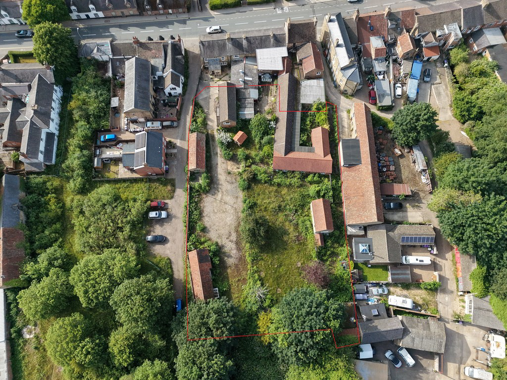
Development Land to Rear of Half Moon Pub
An attractive residential development opportunity located in the heart of the historic market town of Alford. The site benefits from planning consent for a comprehensive redevelopment scheme and we are offering for sale the development site with the ability to create 9no. new-build residential units.The site extends to approximately 0.60 acres in total.BDLD NEHO
The home, in the agent’s words
- Consented Residential Development Opportunity
- Up to 9 Dwellings in the Heart of Alford
- Benefitting from Planning Permission with outline consent for 9no. dwellings
- Prime Town Centre Residential Development Site
- Established residential location
- Close to amenities
- Ideal for developers and investors
Read the full agent description
LOCATION What3words: ///twinkling.intensely.paddlers
The nearest postcode is LN13 9DG
Alford is a popular and sought-after Lincolnshire market town offering a wide range of amenities including independent shops, schools, healthcare facilities, cafés and recreational facilities. The site occupies a prominent position on West Street within easy walking distance of the town centre amenities.
ACCESS Access to the site is off West Street. The access is provided over third party land for which the property has an unencumbered at all times for all purposes access, however, no management company has been set up for this privately owned road and therefore there will need to be one implemented for all users for maintainance purposes/
PLANNING East Lindsey District Council has granted a hybrid planning permission under application reference number N/003/01770/24 providing:
Outline Planning Permission for the erection of 9 dwellings, with layout, scale, landscaping and appearance reserved for future approval. The plans retain one existing building formerly known as Rope Walk Lodge as an annexe to Plot 1.
Full Planning Permission for the conversion of the existing hotel and restaurant buildings to create 4 residential dwellings. This has received a further planning consent (00099/26/FUL) for the change of use and conversion of ground floor of former public house, which is a listed building, to form a retail showroom on ground floor falling within Use Class E (a): Retail, with use of existing apartment and hotel bedrooms above to provide single unit owner occupier residential accommodation. N.B. this parcel is not available as part of this sale.
All matters relating to access, appearance, landscaping, layout and scale are reserved, presenting flexibility for a purchaser to tailor the scheme to their own requirements, subject to reserved matters approval.
Full details can be found at https://publicaccess.e-lindsey.gov.uk/online-applications/applicationDetails.do?activeTab=documents&keyVal=ZZZO8RZZAX946
PLANNING CONDITIONS The permission is subject to a number of planning conditions, including matters relating to contamination, ecology, drainage, archaeology, biodiversity net gain, construction management and reserved matters approval. Interested parties should satisfy themselves as to the requirements and associated costs of complying with all planning conditions.
DEMOLITION The purchaser will be obligated to demolish any shared buildings that fall within the land for sale and in accordance with statutory and planning requirements. This will need to be done in liaison with the existing owner of the Half Moon Pub who is obligated to demolish any shared buildings that are situated on their land within 3 years of their purchase (being January 2026).
S106 S106 contributions are required under planning application N/003/01770/24. Based on 13 new residential unit's both the NHS and the Education Authority have requested contributions. A S106 agreement was recommended to secure a contribution to improve the bus stop adjacent to the site.
Given this is an outline application, the number of dwellings proposed could vary, along with the housing types. Therefore, the actual amount may vary. The required contribution will be secured in the relevant way as part of the Reserved Matters application.
COUNCIL TAX AND BUSINESS RATES The property is not recorded on the East Lindsey District Council website for council tax purposes but any residential occupation such as that for which permission has been granted would alter this position.
SERVICES CONNECTED It is anticipated that the development will be connected to mains drainage, gas, electricity and water as available. Applicants should satisfy themselves as to the precise position and accessibility of these services.
WAYLEAVES, EASEMENTS, COVENANTS AND RIGHTS OF WAY The land is sold subject to and with the benefit of all existing wayleaves, easements and quasi-easements and rights of way, whether mentioned in these particulars or not.
TENURE The land is offered for sale freehold with vacant possession on completion.
VAT VAT is not anticipated to be chargeable in addition the agreed sale price.
BOUNDARIES The Purchaser(s) will be responsible for establishing a boundary treatment (tbc) to demarcate the new boundary to the north following demolition of the buildings and completion of the sale.
SPORTING AND MINERAL RIGHTS These are included in the sale where they are owned.
SALES PACK Further information, planning documentation and supporting reports are available upon request.
VIEWING Strictly by prior appointment through the selling agent.
METHOD OF SALE The property is offered For Sale by Private Treaty.
DIRECTIONS From the centre of Alford in the market place, proceed west along West Street and the site can be found a short distance on the left hand side, as identified by the sale board.
GENERAL INFORMATION The particulars of this property are intended to give a fair and substantially correct overall description for the guidance of intending purchasers. No responsibility is to be assumed for individual items. No appliances have been tested. Fixtures, fittings, carpets and curtains are excluded unless otherwise stated. Plans/Maps are not to specific scale, are based on information supplied and subject to verification by a solicitor at sale stage.
The marketing photos were taken in May 2026, and the particulars were prepared in June 2026.
A feel for the area
Connected for everyday life
76%of homes in the postcode can access 100+ Mbps broadband.
Available speed bands
- 30+ Mbps
- 100%
- 100+ Mbps
- 76%
- 300+ Mbps
- 76%
- 1,000+ Mbps
- 76%
Getting about
9.6 milesto Thorpe Culvert Rail Station
Approximate straight-line distance · DfT NaPTAN · 13 Sept 2026Background air quality
- Fine particles · PM₂.₅
- 6.6 µg/m³ · Above the WHO guideline · well within the UK legal limit
- Nitrogen dioxide · NO₂
- 4.3 µg/m³ · Meets the WHO guideline
Annual background levels. For scale: the WHO 2021 guideline is 5 µg/m³ for PM₂.₅ and 10 for NO₂; the UK legal limit is 20 and 40. Lower is better; this is a 1 km model, not a reading at the door.
Defra · 2024 annual model · 1 km areaLocal information is approximate. Distances are straight-line estimates from the available location. Broadband describes postcode coverage, not the speed or service available at this home; check the address with a provider. Air quality is a modelled annual background estimate.
Checking nearby places…
Picture your everyday
Start with the agent's details and explore the area guide to get a feel for daily life here.
Other homes nearby
Homes in LN13 postcode area →About these property details
The information provided in this listing is for general information purposes only and does not constitute property particulars. We make no warranties or guarantees, express or implied, regarding the accuracy, completeness, or availability of the information.
Property details are provided by the listing agent, developer, or other third parties, and we have no control over the content provided. Prospective buyers or tenants should make their own enquiries and verify all information directly with the agent or relevant party.
Information relating to Energy Performance Certificates, Home Reports, or other statutory documents should be obtained directly from the selling agent or developer where applicable.