

Ripon, North Yorkshire · HG4
Copt Hewick
Guide price
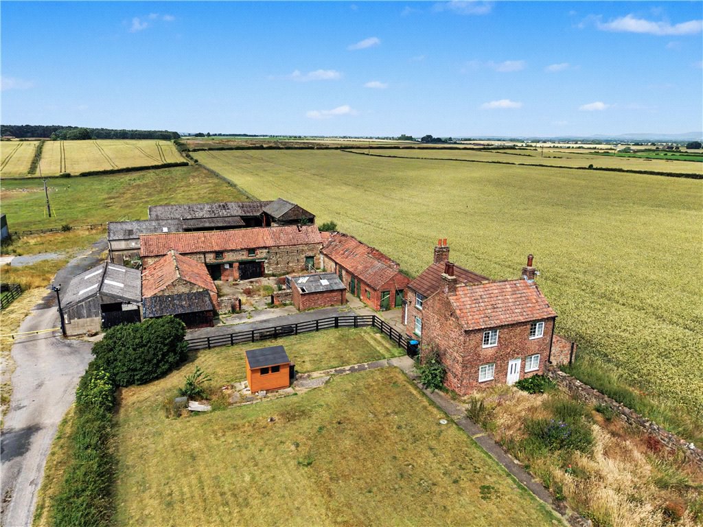
A mainly arable farm comprising a modest farmhouse with a range of traditional and modern farm buildings and productive arable land extending to about 96.93 acres (39.23 ha), predominantly within a ring fence. It is located in a very accessible & sought after location within the heart of North Yorkshire, between Ripon and Thirsk.
The home, in the agent’s words
- A mainly arable farm extending to 96.83 acres (39.25ha)
- Modest three bedroom farmhouse
- Extensive range of traditional farm buildings
- Modern farm buildings
- Sought after & convenient location between Ripon & Thirsk
- Outbuildings
Read the full agent description
The Property
Marrow Flatts Farm comprises a ring-fenced block of productive Grade 2 Agricultural Land extending to approximately 95.69 acres (38.73 ha), the majority of which is arable along with permanent pasture and a small area of woodland.
The farmstead extends to approximately 1.24 acres (0.50 ha) and comprises a modest 3 bedroom brick built farmhouse with an adjoining outbuilding/store. There is an extensive range of traditional farm buildings set around a fold yard with garaging. There is a further range of more modern farm buildings and stores.
The farm is offered for sale as a whole.
The Farmhouse – The farmhouse is brick built under a pantile roof and extends to approximately 1172 sqft. It offers an entrance vestibule leading to the breakfast kitchen, sitting room, dining room, wet room and pantry. To the first floor there are three bedrooms with one having a shower room. To the rear of the property is an adjoining outbuilding/store. The property does require some upgrading.
Farm Buildings – The farm buildings comprise a range of traditional brick & cobble single & two storey buildings set around a central fold yard with adjoining stores. There is a Dutch barn to the north with modern steel portal framed buildings beyond which include two grain stores and a machinery store. The main steel portal framed building is in good condition and is an excellent general purpose & grain store. Some of the buildings need some repair, whilst the traditional range has limited use for agriculture, but may be considered as having scope for alternative uses, subject to obtaining all the necessary consents.
Please see building plan showing both the traditional and modern buildings.
The Farmland – The farmland extends to approximately 95.69 acres (38.73 ha) in total and is Grade 2 agricultural land. Much of the land is ring-fenced arable amounting to approximately 86.49 acres (35.00 ha) and the planned cropping for Harvest 2027 together with the previous cropping history is shown in the table after the field plan. Approximately 7.47 acres (3.02 ha) is permanent pasture and is currently grazed with sheep. There is also 1.73 acres (0.70 ha) of woodland including a useful hardstanding.
Agent's Notes:
Vacant possession of the house, buildings and grassland will be available on completion. The arable land is subject to a Farm Business Tenancy that expires on 31st August 2027.
Development Value - The property will be sold subject to a developement overage clause. If the buildings or land obtain planning consent for development other than Agricultural or Equestrian use within the next 25 years the vendor will be entitled to receive 50% of the increase in value.
A feel for the area
Connected for everyday life
75%of homes in the postcode can access 100+ Mbps broadband.
Available speed bands
- 30+ Mbps
- 75%
- 100+ Mbps
- 75%
- 300+ Mbps
- 75%
- 1,000+ Mbps
- 75%
Getting about
6.8 milesto Thirsk Rail Station
Approximate straight-line distance · DfT NaPTAN · 13 Sept 2026Background air quality
- Fine particles · PM₂.₅
- 5.2 µg/m³ · Above the WHO guideline · well within the UK legal limit
- Nitrogen dioxide · NO₂
- 4.1 µg/m³ · Meets the WHO guideline
Annual background levels. For scale: the WHO 2021 guideline is 5 µg/m³ for PM₂.₅ and 10 for NO₂; the UK legal limit is 20 and 40. Lower is better; this is a 1 km model, not a reading at the door.
Defra · 2024 annual model · 1 km areaLocal information is approximate. Distances are straight-line estimates from the available location. Broadband describes postcode coverage, not the speed or service available at this home; check the address with a provider. Air quality is a modelled annual background estimate.
Checking nearby places…
Picture your everyday
Start with the agent's details and explore the area guide to get a feel for daily life here.
Other homes nearby
Homes in HG4 postcode area →About these property details
The information provided in this listing is for general information purposes only and does not constitute property particulars. We make no warranties or guarantees, express or implied, regarding the accuracy, completeness, or availability of the information.
Property details are provided by the listing agent, developer, or other third parties, and we have no control over the content provided. Prospective buyers or tenants should make their own enquiries and verify all information directly with the agent or relevant party.
Information relating to Energy Performance Certificates, Home Reports, or other statutory documents should be obtained directly from the selling agent or developer where applicable.