
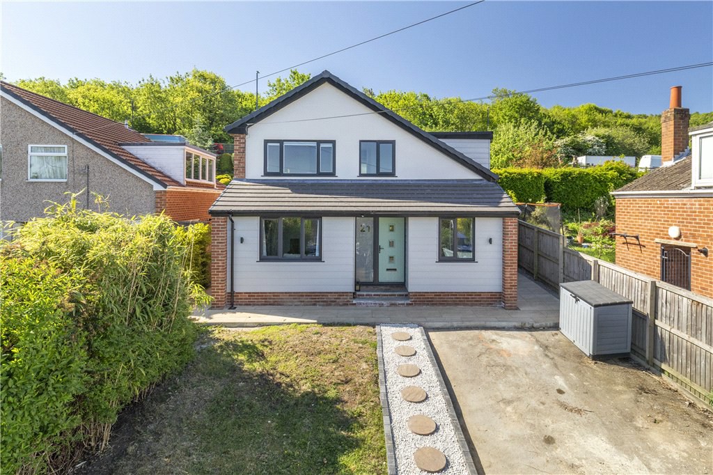

Otley, West Yorkshire · LS21
Lisker Avenue
Guide price
A recently and vastly improved four bedroom detached family home with a substantial open plan living area split into sitting, dining and kitchen portions, plus study, utility and additional shower room. There are four first floor bedrooms, house bathroom and a southerly facing garden and balcony plus ample parking in a child friendly cul-de-sac location close to All Saints Primary School.
The home, in the agent’s words
- Extended and improved detached family home
- Flexible living space arranged over two storeys
- Impressive living / dining kitchen area
- Four bedrooms
- Feature full width southerly facing balcony
- Parking facilities and gardens to the property's front
- Child friendly cul-de-sac
- Close to All Saints Primary School
Read the full agent description
21 Lisker Avenue was purchased by our clients in 2021 and in the intervening period has been subject to a massive programme of extension and improvement.
As the plans show there is a feature living space split into sitting, dining and kitchen areas with aluminium bifold doors leading to the southerly facing rear garden which has seating built into the retaining wall .
The high quality fitted kitchen incorporates numerous appliances, quartz worktops and underfloor heating which continues into the utility room and shower room. Two further reception areas can we found to the ground floor, one is currently used as a study.
To the upper storey are four bedrooms of varying sizes plus a house bathroom. Of particular note is the full width contemporary balcony overlooking the southerly facing rear gardens approached via the master bedroom.
The property is located at the top of a small and peaceful cul-de-sac in a most sought after residential neighbourhood close to All Saints Primary School and is approximately a 10 min walk into the Otley town centre.
Otley's active and historic market town offers excellent shopping and recreational facilities, three national supermarkets, a good range of independent shops and a central bus station.
Excellent schooling in all age groups including the acclaimed Prince Henrys Grammar School
The surrounding business centres of North and West Yorkshire including Leeds, Bradford, Harrogate and York are within comfortable daily travelling distance by road. There is the town centre bus station with bus services to Menston's railway station with main line links to Leeds and Bradford and there is the Leeds/Bradford International Airport at nearby Yeadon.
Local Authority & Council Tax Band
• Leeds City Council
• Council Tax Band D
Tenure, Services & Parking
• Freehold
• Driveway
• All mains services
Agent’s Notes If any issue such as location, communications or condition of the property are of material importance to your decision to view then please discuss these priorities with us before making arrangements to view. Please note: photos taken May 2025
Internet & Mobile Coverage
The Ofcom website https://checker.ofcom.org.uk/ shows internet available from at
least 1 provider. Outdoor mobile coverage (excl 5G) likely from at least 1 of the UK’s 4
main providers. Results are predictions not a guarantee & may differ subject to
circumstances, exact location & network outages
Flooding
Check for flooding in England
-
GOV.UK indicate the long term flood risks for this property are:
-
Surface Water - Very Low
-
Rivers & the Sea - Very Low
-
Flooding from groundwater is unlikely in this area
-
Flooding from reservoirs is unlikely in this area.
A feel for the area
Connected for everyday life
100%of homes in the postcode can access 100+ Mbps broadband.
Available speed bands
- 30+ Mbps
- 100%
- 100+ Mbps
- 100%
- 300+ Mbps
- 100%
- 1,000+ Mbps
- 100%
Getting about
2.3 milesto Guiseley Rail Station
Approximate straight-line distance · DfT NaPTAN · 13 Sept 2026Background air quality
- Fine particles · PM₂.₅
- 6.1 µg/m³ · Above the WHO guideline · well within the UK legal limit
- Nitrogen dioxide · NO₂
- 6.9 µg/m³ · Meets the WHO guideline
Annual background levels. For scale: the WHO 2021 guideline is 5 µg/m³ for PM₂.₅ and 10 for NO₂; the UK legal limit is 20 and 40. Lower is better; this is a 1 km model, not a reading at the door.
Defra · 2024 annual model · 1 km areaLocal information is approximate. Distances are straight-line estimates from the available location. Broadband describes postcode coverage, not the speed or service available at this home; check the address with a provider. Air quality is a modelled annual background estimate.
Checking nearby places…
Picture your everyday
Start with the agent's details and explore the area guide to get a feel for daily life here.
Other homes nearby
Homes in LS21 postcode area →About these property details
The information provided in this listing is for general information purposes only and does not constitute property particulars. We make no warranties or guarantees, express or implied, regarding the accuracy, completeness, or availability of the information.
Property details are provided by the listing agent, developer, or other third parties, and we have no control over the content provided. Prospective buyers or tenants should make their own enquiries and verify all information directly with the agent or relevant party.
Information relating to Energy Performance Certificates, Home Reports, or other statutory documents should be obtained directly from the selling agent or developer where applicable.